Out for the day in Leucate
WALK THE REGION WITH TIM AND CHRIS PARKER
Leucate: plateau, cliffs and coast
A circular, 4 hour / 12 km* walk at low level with just 120m of ascent. Rocky paths with some sections of tarmac on country tracks. Good walking shoes/boots advisable. Sun protection essential IN WARM WEATHER as there is very little tree cover on most of the route.
Really pleasant walk with great coastal sections. Can be ridden by mountain bike (VTT).
| Access: map IGN 1:25000 Durban Corbieres 2547OT |
*Can be shortened to 2.5 hours / 8km by missing the Etang section. Alternatively, can be done as 2 walks on different days, separating the Plateau and Etang.
sections.
START
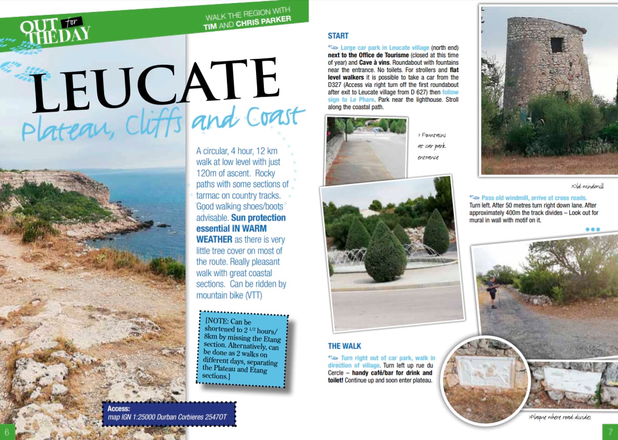
 Large car park in Leucate village (north end) next to the Office de Tourisme (closed out of season) and cave à vins. Roundabout with fountains near the entrance. No toilets.
For strollers and flat level walkers it is possible to take a car from the D327 (Access via right turn off the first roundabout after exit to Leucate village from D 627) then follow sign to Le Phare.
Park near the lighthouse. Stroll along the coastal path
THE WALK
 Turn right out of car park, walk in direction of village. Turn left up rue du Cercle – handy café/bar for drink and toilet! Continue up and soon enter plateau.
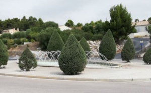
Pass old windmill, arrive at cross roads. Turn left.
After 50 metres turn right down lane. After approximately 400m the track divides – look out for mural in wall with motif on it.

Take left fork and continue for about 750m. At left hand bend take track on right between 2 stone walls. Arrive at crossroads and turn right.
Follow this track past an old Bergerie – remnant of an age when sheep were grazed on the plateau.

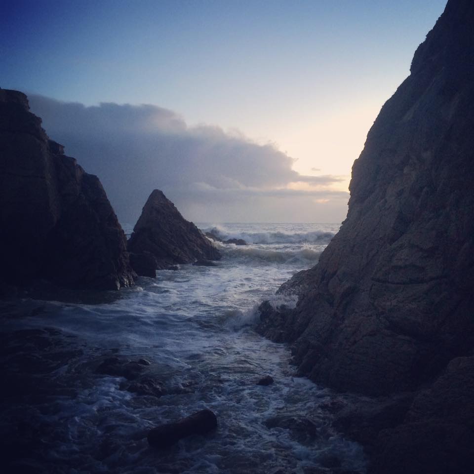
The path narrows. On reaching wider track, turn right. After 50 metres take left fork and head for the cliffs, emerging at Cap des Trois Freres

Pass car park, walk into road with “no through road” sign. Turn right between a house and a high wire fence. Keep high on footpath next to fence and
take in lovely views of Leucate Plage and beyond.
After about 400m, go down series of steps edged with wood, cross road, continue to quickly find second series of steps. Bend left at bottom of steps onto concrete. Reach side road.
Turn right and then right again along the main residential street. At end of street cross road to pick up cycle track and follow it across main road junction to reach roundabout at entrance to Leucate village.
You will have had D627 and Etang on left and D327 on your right, while you are away from all the traffic.
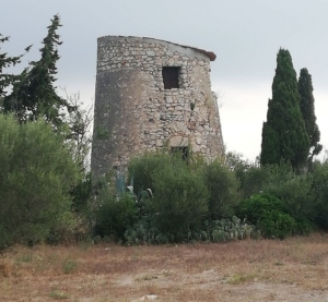
CONCHYLICULTURE; THE WORLD IS YOUR OYSTER!
French poet Leon-Paul Fargue described eating oysters as like ‘kissing the sea on the lips’.
Exotic, erotic by reputation… and not everybody’s tasse de thé, the salty, nutty, aromatic and erotic Leucate oyster has been farmed since 1963 on the narrow strip of beach which separates the Med from the freshwater lake, creating a mix of fresh and sea water, perfect conditions for quality oysters.
With nearly 80% of its massive 600 to 800 tonne production sold directly in Leucate, you can be pretty sure your oysters are fresh.
Enjoy with a glass of Leucate wine in one of several rustic oyster shacks, most of which are open much of the year. Often served with lemon, chopped shallot and red wine vinegar dressing.
| OPTION HERE OF SHORTENING THE WALK BY FOLLOWING THE ROAD SIGNED TO LEUCATE VILLAGE AND BACK TO CAR PARK. |
To continue beside the Etang cross the D 627 just before the roundabout and turn left on a track, following the edge of the Etang. At a house, it is
possible to make a slight detour to la grotte des Fées.
LA GROTTE DE FÉES
This Chalcolithic (2000-1800 BC) and later Roman occupied site of 5 caves was discovered in 1909.
Skulls, large blades and flint knives, axe polisher, ornate pottery and jewellery were found, as well as clay figures, believed to be ex-votos, offered up to the Gods by locals of Leucate for favours granted.
Several entrances lead to submerged galleries. It was classified as a Historical Monument in 1924 but is not open to the public.
The main track passes a creek and then gradually becomes narrower, with red markers. Later reach a wider track and continue past a campsite, ignoring
all tracks off the main one, to reach a tarmac lane.
Go up the lane and under the D627 and head upwards between 2 dry stone walls. At a pine grove, turn left on a track, follow the red markers and head
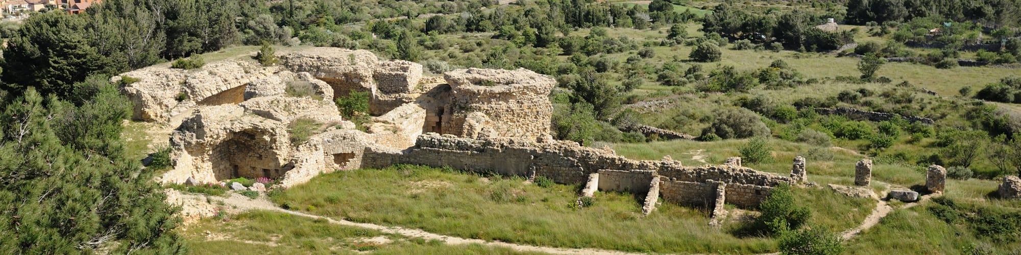
up to the ruined chateau de Leucate. Great viewpoint!
LE CHATEAU DE LEUCATE
The site of the chateau was of some strategic importance, forming the frontier between France and Aragon. The Treaty of the Pyrenees in 1659 moved the borders and Louis X1V ordered its demolition, due to the cost of its upkeep to the crown.
Parts of its original design were quite avant-garde for its time, designed by Italian architects, one of whom was Léonardo de Vinci. Today, the ancient ruins look out over stunning views of the salt lake, the sparking Med, Canigou and the Albères mountain range.
The route down leads to the Place de la République, with the statue of Francoise de Cezelly, who saved Leucate when it was attacked by Spain in 1590.
Make time to explore the attractive village centre and take some refreshment before making your way back to the car park.
FRANÇOISE DE CEZELLY
“La ville est au roi et mon honneur est à Dieu. Je dois les conserver jusqu’à mon dernier soupir”.
This French war heroine led the successful defence of Leucate when it was besieged by Spanish forces in 1590. Her husband, the governor, was captured
and imprisoned, his life offered in return for the surrender of the town.
She refused.
He was executed but the town was saved.
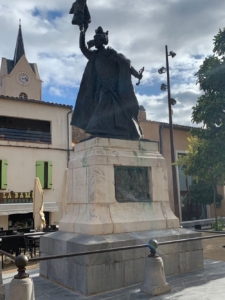 In 1899 a bronze statue was erected in her honour in the Place de la République in Leucate. Designed by Toulouse sculptor Paul Ducuing, she held the keys to the town.
In 1942, the statue was melted down by the collaborating Vichy government and shipped to Germany. As it was being moved, the hand holding the keys broke off.
A Leucate resident managed to grab the broken hand and take it to the mairie. Once again, Francoise Cézelly had not surrendered the keys to the enemy! You can still see the hand today in the Town Hall.
An exact replica of the statue replaced the original in 1975.
As featured in P-O Life n° 66 (winter 2019/20)