Walk the Region ……… with Mike Rhodes
Lac de la Balmette, Mont Llaret 2376m & Roc D’Aude 2325m.
Access: Map IGN 1:25000 Font Romeu 2249ET. Park by the telecabine Les Pelerins in Les Angles at 1650m 31N 423652E 4713989N.
 ACCESS
This classic tour of the Capcir plateau follows good footpaths, way-marked in yellow and takes around 6 hours, starting and ending in Les Angles village centre.
In early summer the wild flowers are magnificent and the views over the Pics Peric are stunning.
Although the paths are good, this is a high mountain walk with 900m of height gain and where the weather can change quickly, so make sure that you can navigate well and take suitable clothing. Poles may help your knees on the final 700m descent!!
WALK
 From the telecabine follow the Mermet piste for 500m to where the Llaret piste joins it from the right.
Although you can take the Llaret piste it is more pleasant to take a path just to the right which leads to le chateau d’eau.
Cross the road and take a forestry track, signed La balmeta, with nice views of lac Balcere and the valley de Vallserra.
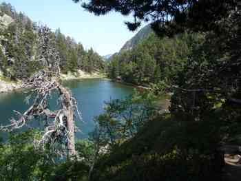
At the end of the piste take a footpath leading through the Scots Pine forest to estany de la Balmeta. ( Since 1983 IGN have been replacing the French map names with local (Catalan), historical names, hence Balmette & Balmeta)
The path 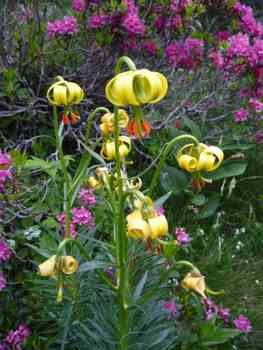 contours the LH side of the lake through the azaleas and climbs a rocky hillside (look out for an area of Pyrenean Lilies) and into a small valley leading to the cabana la Balmeta.
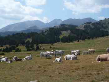
The cabana was a shepherd hut but now “les vacheurs” use an encampment about 500m away and look after 400 cows each summer.
To your right (North) you will see the imposing south ridge and summit of Pic Peric 2810m, a rouite to savour for another day.
Take a peep inside the cabana and you will see a sleeping “dortoir” to the left and a small eating area and fireplace to the right. This is a popular, if informal, refuge for walkers.
From the cabana head towards Lac de Bouillouse on the Tour de Capcir path for 700m when you will see a path on your left (west) heading towards Mont Llaret. Take this path, which this year was marked by small, waymarked posts in the ground, taking care after 1km where the path to the Lac d’Aude goes off to the right.
If you start descending then you have gone wrong as our path continues up the hill to the summit plateau at Mont Llaret, 2376m and marked by a cross.
The slope to your right goes down to Lac d’Aude, the source of the river Aude, but beyond there are views to the slopes of Font Romeu, Puigmal 2910m, Sierra de cadi and the limestone spikes of the Pedraforca.
Across to the east lies Roc d’Aude 2325m and the outline of machinery that marks the ski station of Les Angles and the start of our descent.
From the top of the ski lifts, follow the piste, Mermet, initially to the SE until you can see the telecabine station. In July & August you can descend by the cabine for free but if it’s not working or you are still feeling fit, follow Mermet piste down to the Jassettes café and junction with Llaret piste which is followed all the way back to the village.
The LH branch of the piste above the village leads directly to the bar Eden Roc where that first beer will taste like nectar!! In summer make sure that you set off in the cool of the morning and plan to get back to the village by mid afternoon as any storms on a hot day tend to arrive in the late afternoon.
Mike Rhodes is an International Mountain Leader / Accompanateur de Montagne, lives all year in Les Angles and specialises in guided walks in the high mountains and Snowshoe trips in winter. He can be contacted on 0033(0)468043728 email: [mike.rhodes@free.fr or visit his web site at www.pyrenean-trails.com