WALK THE REGION WITH TED AND KATE HISCOCK
Tour de Madeloc & Military Installations
(21.5km [13.5 miles]) 6 hours
This walk crystallises the reasons why we love this region and is the crowning glory to the walks around Port Vendres.
It is the longest, possibly the most challenging of the ones we have done, and offers some of the most sensational views over the region. The going at times is tough and rugged but the rewards well worth the extra effort.
It embraces a walk to Cosprons then up to the Fortress Galline, on to Batterie 500 and to the crown of Tour de Madeloc at 656m, continuing to Batterie Taillefer and then sharply down to tarmac roads for a short while, then sharply back to rugged rocky terrain past Fort Dugommier & Fort St Elme before dropping back to Port Vendres.

If it is wet, very windy, low cloud or a hint that the weather is going to change for the worse, do not do the part of this walk between Tour de Madeloc and Batterie de Taillefer as this part of the walk is dangerous in these conditions. Another precaution is to bear in mind that the walk is about 6 hours long, (including stops totalling about 1 hour), no shops, toilets and therefore adequate water & food supplies are essential.
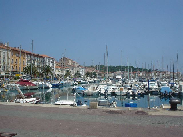
Starting from the Place de l’Obélisque, drop down to the port, along rue Pierre Forgas past all the shops and restaurants, turn left along the back of the marina (Quai Francis Joly) and by the Douane (Customs House) proceed up the steps to the main road into Port Vendres (route de Banyuls).

Continue to the junction by the Hotel Les Jardins du Cedre and turn right down the hill for about 100m, crossing to the other side, [WATCH THE TRAFFIC ON THIS BUSY ROAD] where you will find a ditch behind the retaining wall for the road. Take the simple rough path down into this ditch, which instantly rises up a rocky face by about 2 to 3 metres.
An obvious rocky footpath rises then up through the wild thicket; passing the modern housing estate high on the right and continues steeply until the narrow D86a road is reached. Turn right onto the road and continue a gentle climb for about 1km, when a sharp bend to the right (a clearing and some tanks on the left) signals the point to leave the tarmac and head left along a bridleway.
The track gently descends to the right between old vineyards with dry-stone retaining walls and as it turns sharply to the right, continue straight ahead, ignoring the one it crosses and descend into a small valley. As it veers to the left, it runs parallel to a track (lower on the left) which opens to more tracks by a small garden.
Continue straight ahead, descending past a holiday home on the left where the path steadily drops between vines to a point just before the bridleway veers sharply to the right. You will see a narrow ditch path falls away to the left, partially obscured by long grass and very little to mark its track. Head down to this path, keeping the Cosprons water tower in front.

Cross the lane, keeping slightly to the right, where immediately the narrow path continues down to a small brook in a ditch and up again passing the water tower and emerging in the hamlet of Cosprons where the chapel of yellow orange stone and low single belfry brings immediate charm to this prosperous but sleepy little community.
As the Route de la Chapelle joins the D86a running through the village, turn right and down the hill to the outskirts of Cosprons.
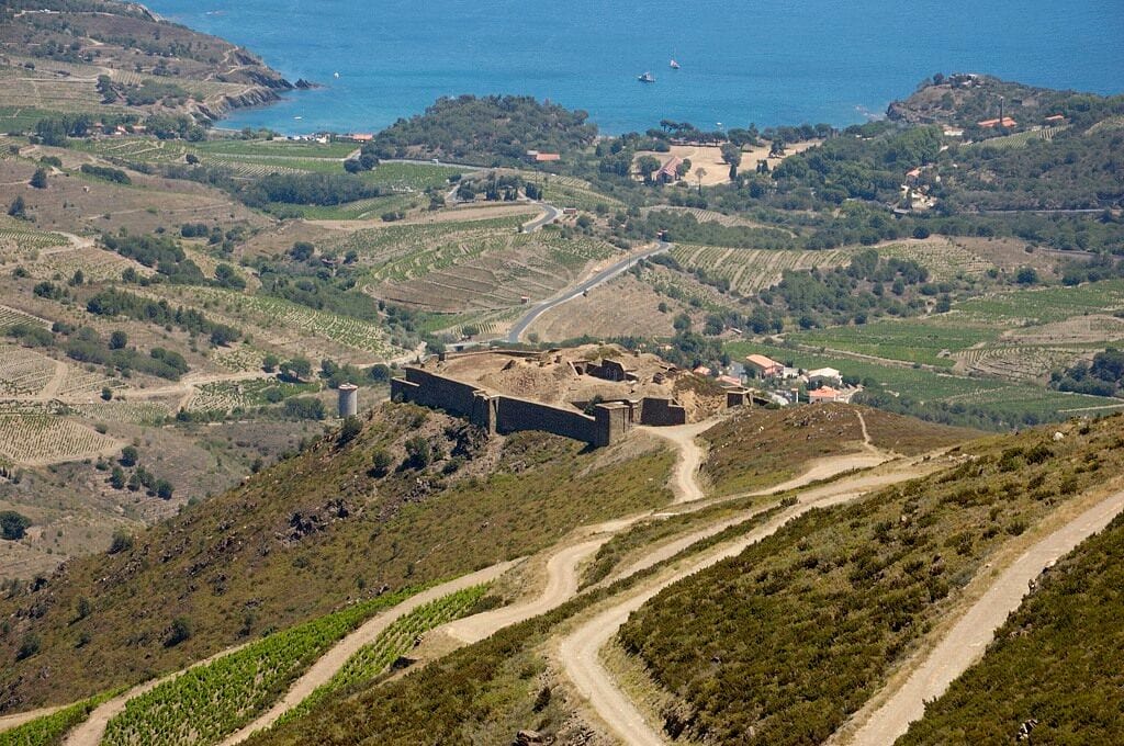
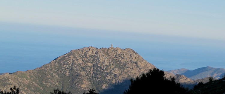
At this point the mountains tower above and with no effort at all, it is possible to see 5 of our seven military installations at once: la Batterie 500, Tour de Madeloc, les Casurnes du Centre, la Batterie de Taillefer and in the eminent central position and closest is La Batterie de la Galline.
Take the right fork in the road, (also signed to the Vinaigrerie de Guineille), which runs parallel to a verdant V shaped valley with ancient gnarled vines (‘vielles vignes’) falling like something from Lord of the Rings on to the road; follow it to a bend which at this point crosses the charming brook Cosprons.

Immediately take the right fork (DO NOT FOLLOW TO THE VINAIGRERIE) and start climbing the narrow cork-oak wooded slope. Although this is still a road for traffic, it is very quiet and only travelled by local residents and vignerons.
With Mother Nature, proudly showing off her colours all around, the road steadily climbs to the seemingly forgotten and charming hamlet of La Guineille at 100m.
Beyond this collection of houses and their well-kept gardens, the metalled surface stops and a dirt track continues. It is rugged but not difficult and the gradient is not severe, as lavender and wild sweet pea predominate this open slope.

La Galline is ever dominant on this climb and towards the top at each hairpin bend, the question is inevitably asked; “Is it not around this next corner?” The views from this track are magnificent as far as the coast out to Cap Béar with its lighthouse; the three beaches at Paulilles and Cap d’Ullastrell are all clearly visible.
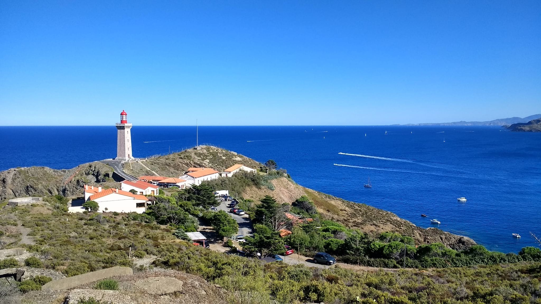
To the South-East Banyuls-sur-Mer comes into view with the Laboratoire Arago, (Paris University Marine Biology department’s large aquarium) is clearly visible at the far end of the promenade. The mountainside here is deeply hewn by steep ravines; they are raging torrents in winter but double as dried ditches and walking tracks during the arid summer months. This is particularly true of the valley of the Callels, which joins the Cosprons at the village by the same name.

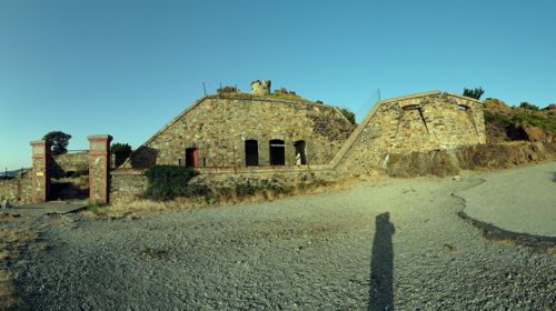
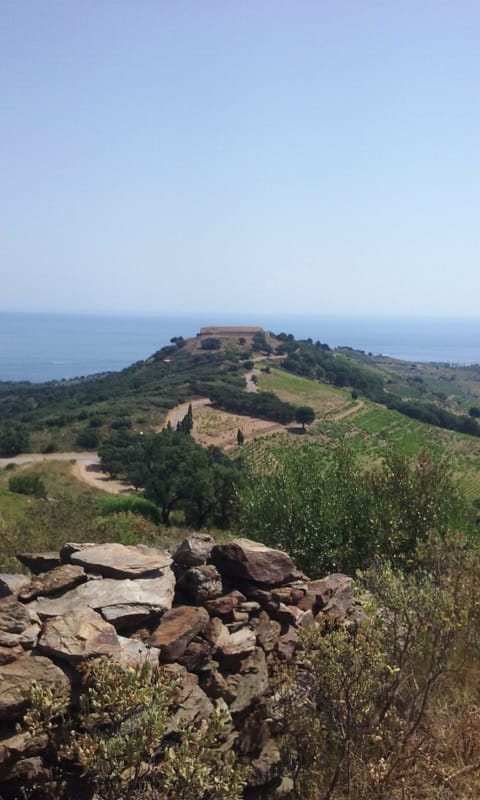
Batterie de la Galline along with Batteries 500 and Taillefer seem a paradox of construction. On the gateposts of Galline’s very impressive drawbridge entry is displayed ‘built between 1885-6’ and one understands it was based on earlier plans of 1846 – but why?
Was it a training ground for French sappers during a boring piece of peacetime, or was there another purpose? No, it was as a lesson learned from the 1870 Franco-Prussian War, when the Spanish opportunistically invaded the Cote Vermeille whilst attention turned on the conflict in the North. Their walls never saw conflict and they have gradually slipped into decline and dereliction.
The climb from Galline to the D86 ‘route de Crete’ is really very gentle, and the surface of this important access track for vignerons is in good condition, (if not with tarmac). When the D86 is reached on a sharp corner, turn right but now start being aware that cars do travel along this narrow strip of tarmac and frequently in the summer months, drivers are tourists admiring the views and not particularly concentrating on the possibility of meeting walkers on hairpin bends.
After about 1km a junction appears where a narrow road ascends to the left with road signs for ‘No Entry’ whilst the D86 continues winding around the hillside towards the ruined Les Casernes (barracks). The ‘No Entry’ applies only to vehicles and it is up this track for another 1.5km that our path takes us.
This is the point where the real climb commences and although tarmac, no cars will annoy the walker. The first corner reveals Batterie 500 dating once more from 1885/6, but the climb establishes true panoramic views across the whole coast and inland.
It is not difficult to see why military engineers across many centuries have used this stupendous countryside for deployment of troops and constructed fortresses and beacons, nor is the importance of these mountains diminished as a natural defence to protect the very vulnerable plain of Roussillon.
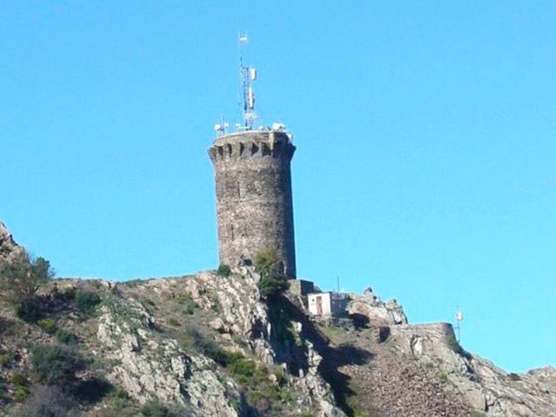
Tour de Madeloc stands at 656m (in English terms about 2000 ft) and is perched on a sharp ridge of schistous rock that falls dramatically on two sides. In the days when cars were permitted to ascend to a pathetically inadequate car park near the summit and accessed by an alarmingly narrow and tortuous single track, passing could be a nerve-racking experience. The tower is used as a transmitter and there is little else apart from breath-taking views and the splendour of unimpeded wild life. The wealth of butterflies and birds at this extreme height tells of the richness of the surroundings.
To descend is an option of three ways…..
1. By continuing beyond, where yellow flashes on the walls indicate the track continuing to Batterie de Taillefer.
2. Retracing exactly the footsteps that brought us up,
3. Retracing the last 1.5km to the D86, turning left and following the vehicular road along the 2km to the crossroads of Col de Mollo, where option 1 ends up. In terms of distance there is little in any of them. The whole walk is between 20 and 21.5km. For the benefit of this description, the route taken is option 1 but in dubious weather conditions, please do take one of the other options.
The first part of the path down from Tour de Madeloc crosses to another transmitter station and then beyond. It is far safer than it may seem at first glance, as it makes rapid and regular twists and turns over shale and rocks. One is tempted to think that it is impossible for a route to exist but it does! There are no handrails (this is France) but sensible behaviour makes this a magnificent experience as the track descends quite swiftly and straightens out pointing towards the next military installation; Batterie de Taillefer at 508m (1500ft).
Just before Taillefer is reached, there seems to be a crossroads of paths and confusing signs. A track comes in from the left – IGNORE and then a bridleway comes up from the right – IGNORE also.
In front, there are two bridleways: one that descends to the right in front whilst the other one hugs the rock at the base of Batterie Taillefer. This latter one is the correct route, however if tiredness is approaching it could be prudent to follow the bridleway as indicated by the signs as this will ultimately drop down more directly on to the D86 with a right turn being only about 0.5km from Col de Mollo.
The stoical will continue on the correct route climbing gently towards the gates of the occupied Batterie Taillefer but on the last corner of the track turning sharply to the left, a yellow flash on a rock indicates this is the way of descent. It is here that the journey becomes slow and care taken as the path in places consists of loose rocks underfoot dropping quite steeply down over what feels like broken teeth to join the D86 where a sharp right turn is taken.
Follow the D86 for about 2km to reach Col de Mollo, which is a junction with four possibilities to take. Follow the sign for Port Vendres, i.e. proceed directly in front for about 1km. As the road opens out into a clearing and sits over a saddle on the hill edge with views to the right to Tour de Madeloc and down to Port Vendres to the left, take a sharp left turn on to a rocky track that climbs up and round to the right, (past a dozen beehives, on the right).
Quite soon, a bifurcation appears in the track, take the right and lower one, which winds around the hillside, initially with a modest ascent but then drops steadily past the shrine to a dead fire fighter who was killed in the line of duty fighting forest fires. Eventually this rocky track joins another simple crossroads of possibilities. Ignore the bridleway that falls sharply away to the right to Mackintosh’s ‘Enchanted Valley’ but take the left tarmac option road, passing Fort Dugommier, Fort St Elme and descend into the higher reaches of Port Vendres.
As the road reaches habitation, keep to the tarmac as it winds around the hillside, and keep the initial houses and gardens on your left until after the straight downhill run passes in front of some duplex properties. At this point a narrow rugged concrete track descends at right angles by a wall on the left after the gardens; follow this down and join the more normal steps in front down to the street and once again continue straight.
Eventually, take one of the set of steps on the right down to the port, turn left and back along the final path to the Place de l’Obelisque.
ALL ALONG THE WATCHTOWER. Find out about other watchtowers in the region.