Montner – Força Réal Circular Walk
With Chris and Tim Parker
A rewarding circular walk of approximately 3 hrs 15 mins with around 380 metres of ascent. The route descends first to the Catalan village of Montner before climbing steadily to the spectacular summit of Força Réal, returning to the Col del Bou via the Sentier Botanique.
Waymarking: Yellow markings throughout.
Map: IGN 1:25000 – Thuir / Ille-sur-Têt 2488 OT
Access
Start: From Perpignan follow the River Têt on the N116 direction Ille sur Têt. Take the exit for Millas. Go through the town, turning right to cross the river Têt. Continue following signs for Força Réal, turning left at the roundabout once across river, and climbing on D612 to the Col de la Bataille. Turn right onto D38 towards Força Réal and park at the Col del Bou, where parking is available beside the road about 1km from the Col de la Bataille.

A Mountain of Frontiers, Fortresses & Resistance
Força Réal occupies a commanding position above the Roussillon plain and for centuries formed part of the frontier zone between the kingdoms of France and Aragon. Built in 1258 by the Kings of Aragon, the original fortress and signal tower formed part of a chain of defensive beacons stretching across the region.
Before the royal fortress existed, the mountain was known as Mont Ner — the “Black Mountain” in Catalan — a name preserved today in the nearby village of Montner.
After the treaty of Bayonne, which set the borders between France and Spain, the King of Aragon, Jean II, handed over the Roussillon and the Cerdagne to Louis XI of France. Years later, Louis’s successor, Charles VIII, decided that the rebellious Roussillonnais were a nuisance – he no longer wanted them – and handed them back to Spain!
In 1496 this fickle king changed his mind again, marched back into the Roussillon and waged war to win back the region, a decisive battle which took place on the Col de la Bataille, as it was subsequently named.
Nothing now remains of the original medieval fortress destroyed during later conflicts, but the summit has continued to evolve through the centuries — fortress, signal tower, hermitage, weather sanctuary and modern fire-watch post.

Col de la Bataille & the Resistance Memorial
Near the Col de la Bataille stands a moving memorial to members of the Resistance group Henri Barbusse during the Second World War.
Their leader, Captain Julien Panchot, became one of the most important figures of Catalan Resistance memory in the Pyrénées-Orientales. Operating from the nearby maquis strongholds and the abandoned mines of La Pinosa, resistance fighters sheltered refugees and organised escape routes through the mountains.
In August 1944, following resistance activity in the area, German troops destroyed the nearby village of Valmanya (Great valley in Latin) in reprisal. Villagers unable to escape into the mountains were killed and much of the settlement was burned to the ground. The rebuilt village today remains a symbol of Catalan resistance and resilience.

Julien Panchot, along with other members of the group, was interrogated, tortured and shot by the Germans whilst defending the villagers. Archive records state “il lui ont brisé les tibias avec une barre a mine attachèe sur une table pour le faire parlè”.
The Walk
- From the parking area at the Col del Bou descend behind the parking area and turn left onto the broad track signposted for the Montner–Força Réal circular walk.
- After approximately 100 metres, take the footpath on the left which contours briefly before descending to a small stone cabin (around 15 mins from the start).
- Turn right onto the grassy track leading down to a tarmac road. Turn right along the road around a left-hand bend and then take the track on the left. Yellow lines indicate the correct route while yellow crosses mark paths not to be followed.
- The tarmac soon becomes a stony farm track passing a concrete utility hut before descending steadily towards the village of Montner (approximately 1 hour from the start).
Montner
- Cross the village and take Rue de Força Réal on the right. At the end of the street keep left through newer housing before leaving the village.
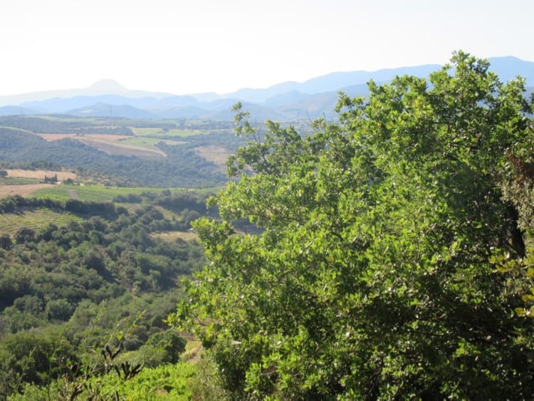
- Just before a small pumping station take the marked track on the right into the vineyards. The route winds uphill through vines producing Côtes du Roussillon wines, with increasingly expansive views across the Ribéral plain.
- At a sharp bend in the small valley, leave the road by taking the track left into the vines and immediately right beside a hedge, marked by a cairn.
- The climb becomes steeper and rockier before finally reaching the flat circular area beside the D38 below the summit of Força Réal.
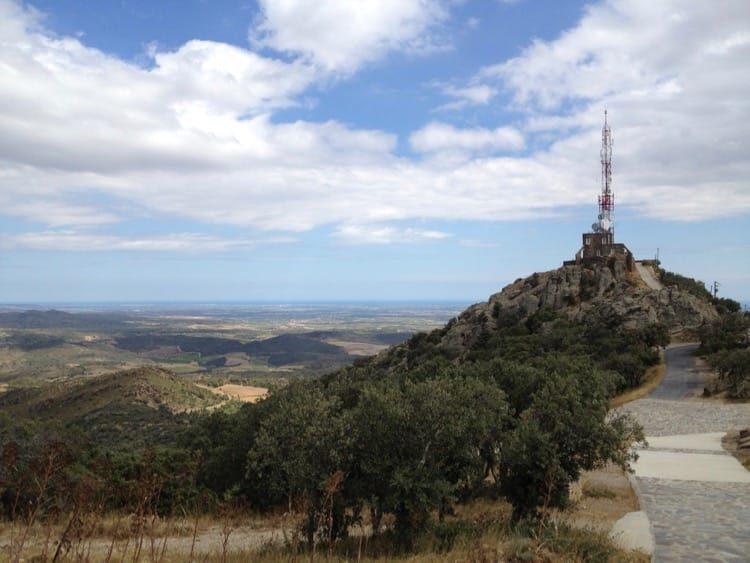
Força Réal Summit
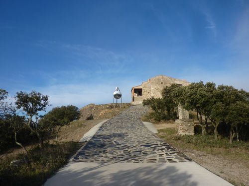
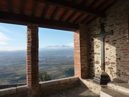
The short final ascent is richly rewarded. From the summit, panoramic views extend from the Mediterranean coast to the Corbières, the Fenouillèdes hills and the snow-capped Canigou massif inland. The summit presents a striking contrast between ancient and modern: the white and red telecommunications mast alongside the peaceful Ermitage de Força Réal. For centuries this exposed summit served as fortress, signal tower, pilgrim sanctuary, weather shrine and lookout point. The hermitage later became a conjurador — a sanctuary where priests once performed rituals intended to protect crops from storms, hail and drought brought by the fierce tramontane wind.
The chapel is rarely open outside festivals and saints’ days, though traditional pilgrimages and processions still take place during the summer.
Near the chapel, a polished steel convex mirror beside the path creates unusual photographic reflections of both visitors and the sweeping landscape behind them.
On clear days the views are extraordinary, but the summit is notorious for strong tramontane winds — secure hats, maps and anything else liable to become airborne.

Return via the Sentier Botanique
- To descend, follow the Sentier Botanique from the circular area below the summit, or walk a short distance down the road to pick up the botanical trail on the right.
- Two variants descend towards the Col del Bou: one passes to the left of the hill while the other curves around the right-hand side before returning behind the summit ridge.
- The botanical trail introduces many characteristic Mediterranean species including kermes oak, rosemary, thyme, cistus, Aleppo pine and wild asparagus in spring.
- Several steep shortcuts near the end cut across the broad hairpin bends leading back to the Col del Bou.
Local Traditions
Força Réal remains deeply connected to local Catalan traditions. Pilgrimages to the hermitage continue each year, particularly around the Feast of the Assumption in August, when torchlit evening processions descend from the mountain after the Marian vigil,
a religious evening gathering dedicated to the Virgin Mary with prayers, hymns, and a night mass.
Standing high above the plains between the Têt and Agly valleys, Força Réal remains both a landmark and a symbol of Catalan identity — a place where frontier history, mountain landscape and local memory meet beneath the ever-present tramontane sky.
Over the years, Força Réal (Royal Fortress) has been many things to many people! Signal tower and fortress for the defence of the Roussillon, welcoming beacon landmark for returning fishermen, hermitage, and today a ‘tour de guet’ for fire spotting. On a clear day, the view will take your breath away.