UPDATED JANUARY 2026
Walk the Region: Banyuls-sur-Mer
Plage des Elmes – Col del Gascons – Batterie de la Galline – La Guinelle – return
With Tim and Chris Parker
🥾 Quick Facts
- Distance: approx. 12 km
- Time: about 4 hours (walking time)
- Ascent: approx. 400 m
- Difficulty: Moderate
- Terrain: Footpaths, broad tracks, short road sections
- Waymarking: Partial (GR10 red/white + local yellow marks)
- Best season: Autumn to spring, or cooler/cloudy summer days
- Map: IGN 1:25,000 – Banyuls, Col du Perthus, Côte Vermeille (2549 OT)
- Equipment: Walking boots recommended; poles useful
Notes: Little shade — carry plenty of water
Trail conditions can change after heavy rain, fires or maintenance work. Always check local conditions before setting out.
Start: Plage des Elmes
Take the N914 towards Banyuls-sur-Mer and turn left just before the first beach you reach — Plage des Elmes, a couple of kilometres before the town centre.
Pass the hotel and turn right to reach the public car park, where there is usually some shade from trees. Parking can be busy in high season, so arrive early if possible.
The Walk
From the car park, follow the broad track and pass under the railway bridge behind it. The track runs between vineyard walls and past a mas.
After very heavy rain this track can briefly carry water, but it is dry most of the year. If flooded, an alternative route via Banyuls town leads to the GR10 beyond the station.
After about 5 minutes, the track narrows into a footpath following a dry riverbed — a route well used by locals. Continue for another 5 minutes to steps on the right leading up to a metal footbridge. Climb the steps, turn left and cross.
Beyond the bridge, follow a broad track uphill, bending right at the top. Turn right again where it meets another wide track. Pass a mas with horses, then descend slightly to meet the GR10 near Coll de les Vinyes.
From here, look back for views over Banyuls and towards the white church of Notre-Dame de la Salette above the town.
Continue on the GR10, pass a house and cross the D86 with care. On the far side, a well-defined path climbs gently, cutting across tracks and opening out to views of the Tour de la Madeloc and the Albères mountains.
Follow GR10 waymarks carefully to reach the Table d’Orientation at Col de Llagastera, beside the road.
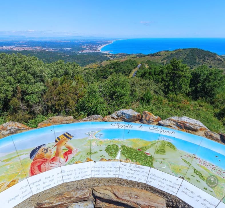
Table d’Orientation
This ceramic orientation table explains how Banyuls wine was once stored in hillside cuves and transported downhill via ceramic-lined channels.
The GR10 briefly follows the road before a footpath on the right leads past the Font del Falgueras and back to the road. Cross again and make the final climb to the D86 near Col del Gascons (387 m). Turn right to reach the col — around 1 hour 35 minutes from the start.
Optional Detour: Tour de la Madeloc
From Col del Gascons, confident walkers can add an ascent to the Tour de la Madeloc. Follow the GR briefly, then strike right towards a battery and join the tarmac road to the summit.
Allow about 1 extra hour return. The views extend over Collioure, Port-Vendres, Banyuls, Cap Cerbère and the Spanish border.
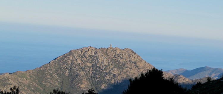
Tours à Signaux
The signal towers scattered across the region date back to the 13th century, built by the Kings of Majorca to relay warnings using fire and smoke. The Tour de la Madeloc (c.1285) was later modified by Vauban.
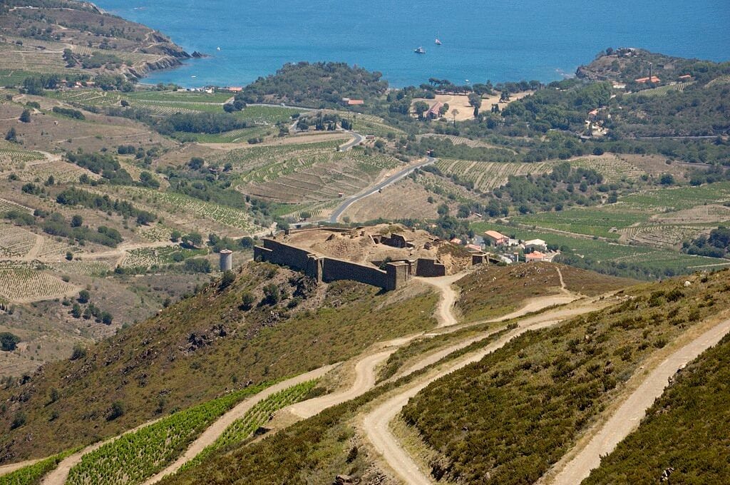
Batterie de la Galline
From the col, walk along the D86 for about 1 km, contouring beneath the Madeloc ridge. As soon as the tower comes into view on the left, look for a sign to La Galline on the right and follow the zig-zag road down to the Batterie de la Galline (around 2 h 20 min from the start).
Built in 1885–86, this imposing fort was designed to deter invasion from Spain. Although it housed up to 70 men, it saw little action. Today, the exterior can be freely explored; restoration work continues under a local association, and interior access depends on open days.
Descent to La Guinelle: Two Options
Continue downhill past the battery entrance, following the piste in wide zig-zags. After about 20 minutes you reach the hamlet of La Guinelle.
Option 1 (shorter)
Just after a sharp left bend, take steps down to a small lane below and join a footpath leading through the valley. Pass the Vinaigrerie de la Guinelle — worth a visit if open — and follow the quiet lane for about 2.8 km to reach the N914 roundabout.
Option 2 (about 1 km longer)
Stay on the road through La Guinelle, cross the bridge and continue into Cosprons. About 750 m beyond, follow signs to Paulilles / Banyuls, descending via track and footpath beside a wall. Pass under the railway bridge near Paulilles and continue alongside the tracks to reach the same roundabout on the N914.
Return to Plage des Elmes
From the roundabout, cross the road carefully and enter the vineyard opposite. Take the footpath immediately on the right, contouring gently through the valley.
Do not rejoin the main road. Instead, follow the path beside the Hélios centre, then turn right at its entrance for views down to Plage des Elmes — an inviting spot for a swim in warm weather.
Alternatively, head into Banyuls-sur-Mer for a drink or dinner, or visit the nearby Biodiversarium.
A Tasty Detour: Vinaigrerie de la Guinelle
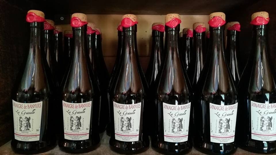
The Vinaigrerie de la Guinelle is the only vinegar producer in France using traditional wine-based, organic methods. Their Banyuls vinegars — red, white and flavoured — are aged outdoors beneath the Mediterranean sun. Opening times vary, so check ahead if you hope to visit… and remember, you’ll have to carry any purchases back!
Practical Notes
- Limited shade for much of the walk — sun protection essential
- Take care on short road sections, especially in summer
- Carry an IGN map or GPS track, particularly in poor visibility
- Best avoided during extreme heat or after prolonged heavy rain
DID YOU KNOW….
GR10- ATLANTIC TO MED
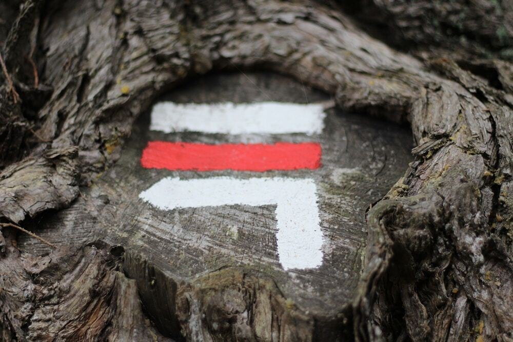
In 1947, the ‘Comité National des Sentiers de Grande Randonnée’ (CNSGR), later to become ‘la Fédération Française de Randonnée Pédestre’, began the creation of the GR or Grande Randonnée network; long-distance footpaths throughout France, Belgium, the Netherlands and Spain, recognised by their distinctive trail indicators of a white stripe above a red stripe.
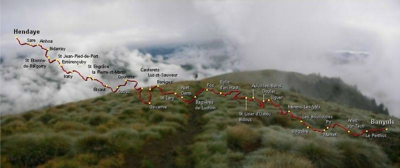
Today, many GR walking routes cross several countries.
In 1964, work started on the GR10 to join the Atlantic to the Mediterranean. The GR10 or ‘Sentier Pyreneenne’ as it is sometimes called, crosses the Pyrenees from ocean to sea via 866 km of indicated walking paths, with 48 km of ascent.
The route follows the French-Spanish border, sticking to the French side. Those attempting the entire trail often choose to do it west-to-east, from Hendaye on the Atlantic Ocean to Banyuls-sur-Mer.
Following red and white paint strokes, it’s a linear walk, mainly waymarked very well, although at times the markings can be difficult to spot.
It is mostly planned so that accommodation can be found at the end of each day’s walk. Many walkers do individual sections over days or weeks, rather than take on the challenge of the whole walk in one go.
Although the footpaths are less demanding than the tracks on the higher level of the mountain (known as the HRP – Haute Route des Pyrenees) it is not an easy option, with some steep climbing, and the full walk apparently would take 50 – 60 days.
The best time for walking the GR 10 is late spring to early summer and late summer to early autumn, as the mid summer heat can be very challenging and the midwinter snow renders some parts of the walk dangerous or impassable.
Find out more here.