Walk the Region: Col Mitja
Col Mitja 2367m, Pic de Gallinas 2624m or Pic Redoun 2677m from Prats Balaguer 1309m.
 This high mountain walk starts from the pretty village of Prats Balaguer (GPS 31N 432043E 4705497N) with its picturesque 11th century church and provides a superb day out with a variety of choices for mixed ability groups, with several starting points and summit options.
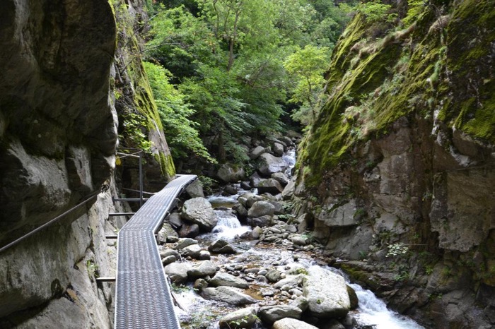
It is also possible to descend into the Caranca Gorge or stay a night at the Refuge de Caranca.
♣ Getting there : Prats Balaguer is just off the road between Prades and Mont Louis. Follow the N116 to Fontpedrouse. Just after the village, signs take you left on the D28, ignoring the turn to St Thomas le Bain, and climb up to Prats Balaguer. (Before modern roads reached the upper valleys, these mountains formed a remote frontier landscape where shepherds, charcoal burners and occasional smugglers knew the terrain far better than any official map.)
♣ The Walk : From Prats involves a climb of 1000m to the col and a further 300m to one of the summits so some parties may wish to park beyond Prats at “Le Bassin” at 1645m (GPS 31N 432716E 4703181N). (13kms from Prats to Col Mitja and return, 6 hours walking.) Allow additional time if you wish to climb one of the peaks. If parking at the Bassin, allow 6 hours return including one of the peaks.
♣ From Prats, follow the track east for 250m and then to the right for a further 420m to where a track branches off to the left, S and then E, climbing steadily, taking the R fork in the track after 20 mins.
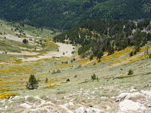
Arriving at the crest of the ridge of Pic Coucouroucouil, 1585m, veer S and climb the SE flanc of the ridge to 1970m where the track descends slightly before climbing again to rejoin the ridge at 1995m. A further 5 mins sees us at the Collet d’Avall 1996m where we join the cross Pyrenees route GR10. After 2 – 2 1⁄2 hours of walking this col makes a great mid-morning stop with views over the Capcir and Tet valley.
♣ From the collet it is possible to follow a wide track all the way to Col Mitja but our route now follows the well way marked GR10 route for another hour to the col, crossing the jeep track at various points. (3 – 3 1⁄2 hours walking.)
♣ From the col we are confronted with several options. Pic de Gallinas (GPS 31N 435492E 4703167N) to the L and Redoun (GPS 31N 434664E 4701733N) to the R are both just less than an hours walk but both offer the most fantastic views from the top. For those wanting to do a circuit via the Caranca Gorge, descend the other side of the pass on good tracks.
(A little curiosity; Gallinas means “hens” in Spanish.)
Towards the bottom the path turns right to the refuge de Caranca 1831m where you may be able to get lunch or stay overnight. The Refuge is staffed during the summer season and offers meals and accommodation. Advance booking is recommended, particularly in July and August.
Just before the refuge you will find the path on the L to Thues Entre Valls via the Caranca gorge taking 3 1⁄2 hours.
♣ Whichever route you chose, from the Col Mitja we are faced with more choices on the descent. It is possible to retrace our steps back to Prats or from Collet d’Avall, either continue descending the jeep track to the parking spot at Bassin or, just below the collet take the footpath to the L through the forest following the GR10 to Bassin.
Both routes take about 90 mins to Bassin. From the LH side of the Bassin pick up a good track that descends towards Prats. In 2 1⁄2 km we join a jeep track by a ruined building “Le Castell” 1388m and Prats is now in view another 10 mins further on.
♣ Whichever route you have chosen you will have had a fantastic day out and will have seen opportunities for further walks in the valleys and peaks to the south towards the Spanish border.
♣ On your drive down from Prats why not stop off at St Thomas le Bain for a dip in the hot pool or for a free dip, park at the first hairpin bend below Prats and take a track to the R where you will find a “source” which you may need to share with ‘like minded’ people.
Emergency: Dial 112 anywhere in the mountains.
(Mountain rescue: PGHM (Peloton de Gendarmerie de Haute Montagne) Osséja 04 68 04 51 03)
Did You Know?
At the Collet d’Avall the route joins the famous GR10, a long-distance trail that crosses the entire French Pyrenees from the Atlantic Ocean to the Mediterranean. The mountains visible from Col Mitja and the surrounding summits were once part of an important iron-mining region whose ore was worked in the traditional Catalan forges of the Vallespir and Conflent.