Motorbiking the region: Orgues, Gorges, Cathars, Romans and Dams
with Leigh & Merry Foster
Key Info Length, circuit from Thuir 111km Approx. 2 1/2 hrs plus stops. This is one of our favourite rides, as it includes some spectacular scenery, lovely winding mountain roads, and lots of fascinating places to stop and explore. You could equally do it by car, but we find the motorbike more fun and easier to pull off the road to look at the beautiful views in safety. |
Start
Our start point is Thuir, but join at any point, depending on where you’re coming from. From Thuir centre, follow D612 to roundabout at edge of town and turn almost 180 degrees towards Ille Sur Têt.
Follow this road for about 14km through charming fruit orchards and vineyards on the Têt plain. Once in Ille sur Têt, follow one-way system, then turn left on D916 towards Prades.
After 200m take right fork towards Sournia, Bélesta and the Site des Orgues. Cross bridge over dual carriageway and river Têt, then at roundabout turn right on D2, still towards Bélesta.
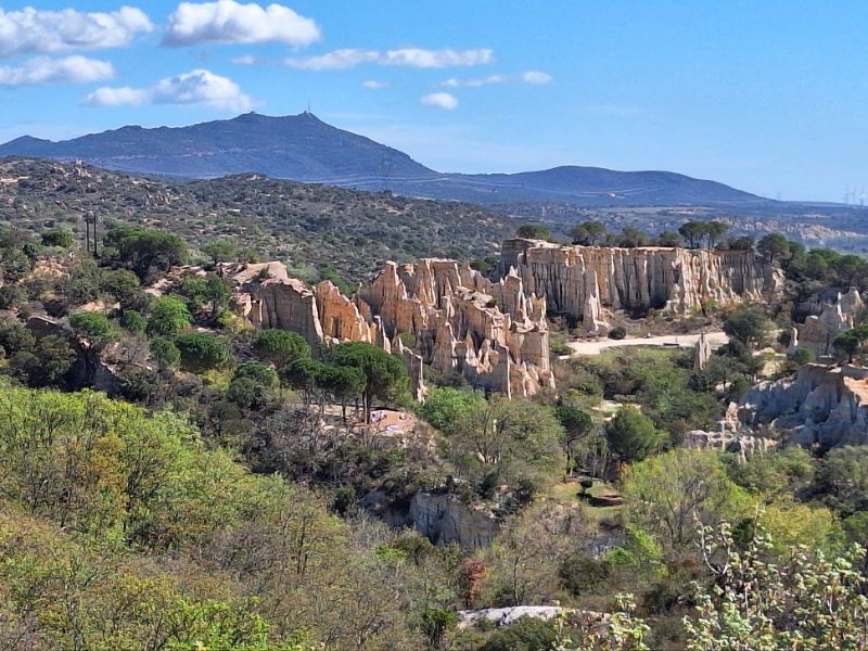
Les Orgues
A striking geological rock formation, these strange limestone cliffs have been sculpted by nature over the last five million years.
The amazing ‘Cheminées des Fées’, clusters of ‘’fairy chimneys, form a natural amphitheatre, a paradise for photographers, a haven for birds and a fascinating walk for visitors who follow the well laid out trail.
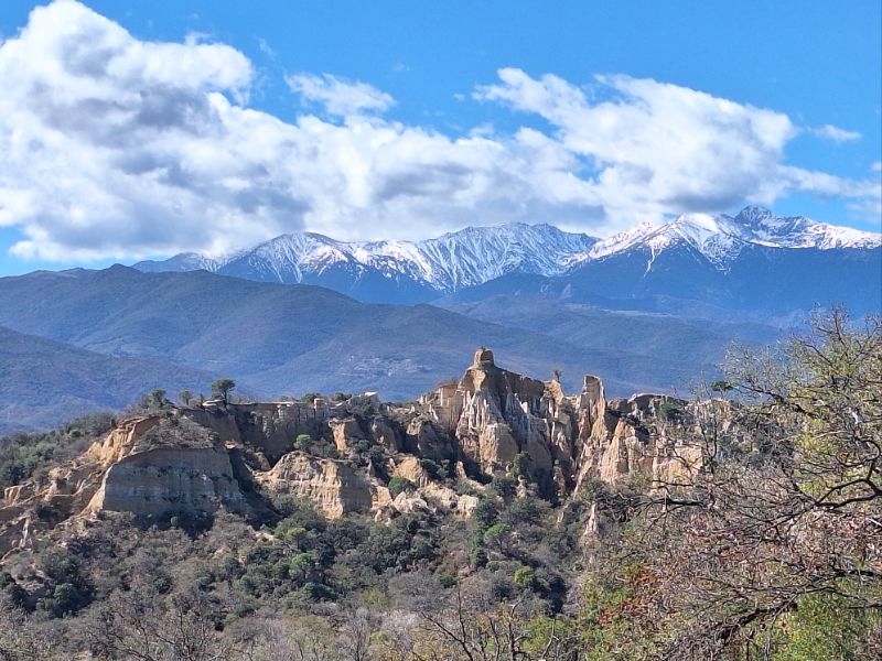
Follow this road as it winds upwards, and after 500m pass the right turn towards the Orgues. Well worth a visit, but if you don’t have time, just keep going on D2 up to the Belvédère des Orgues at junction with D21, 1.3km further on.
Worth a quick stop here for panoramic views east down to Orgues, and southwest towards mighty Canigou, visible behind another dramatic set of sandstone peaks atop small hill north of river. A table d’orientation tells you what you can see on a clear day.
After your stop, continue on D21 following valley de la Riberette. The landscape is mostly wild and rugged, as the road winds its way through the hills. After about 5km, reach the picturesque village of Bélesta, perched on a hillside above a dry riverbed.
Stay on D21 towards Caramany, and enjoy twists and turns through stunning scenery. To the north, the massive limestone peaks of the Corbières, with their Cathar castles marking the border from the P-O to the Aude.
To the west the stark peak of Bugarach, well–known for its mysterious history (legend has it that it is named after two naughty elves, Bug and Arach who annoyed Jupiter so much he turned them into a mountain!).
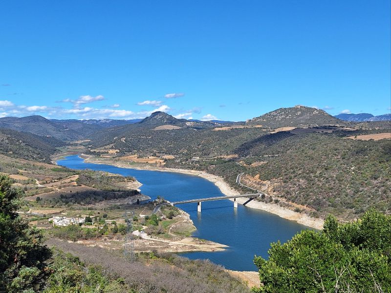
Just over 4km from Bélesta, before entering Caramany, turn off to right to the Belvédère du Lac. The track to the top is marked no entry, but you can park at bottom and walk up to a fabulous shady picnic spot, overlooking the Barrage d’Agly and the reservoir of Caramany.
It is so quiet you can almost hear the butterflies as they glide through the trees. The reservoir was nowhere near full when we were there, but still had enough water to look beautiful.
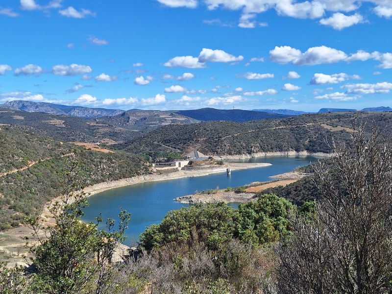
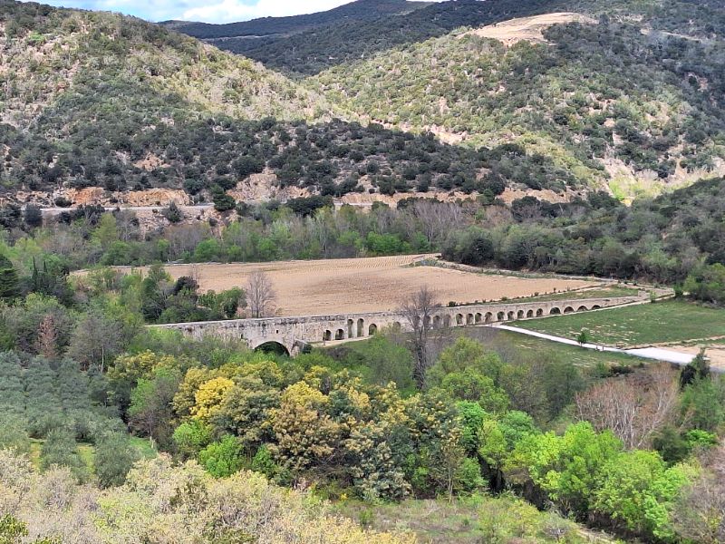
From here, continue down through Caramany and across the reservoir bridge. After about 3km turn left on D9 towards Ansignan (where there is a large Roman aquaduct you can either visit, or look down on from the road) and St Paul de Fenouillet.
Turn right on D619, and the road now follows the Agly as it winds up through the hills and imposing gorges. Pass through the steepest bit and descend into St Paul 9km later.
In the village centre, cross over the D117 and follow the signs to the Gorges of Galamus on the D7. After climbing steadily about 5km, reach the spectacular gorge.
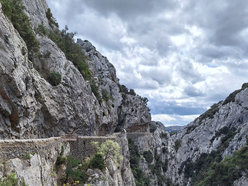
There is a car park and a snack bar where you can take a break and marvel at the 14th century hermitage hanging on a cliff above the deep river valley.
Again, if you have time to visit, there is a rough footpath, and it is amazing to wonder how on earth they built it so long ago.
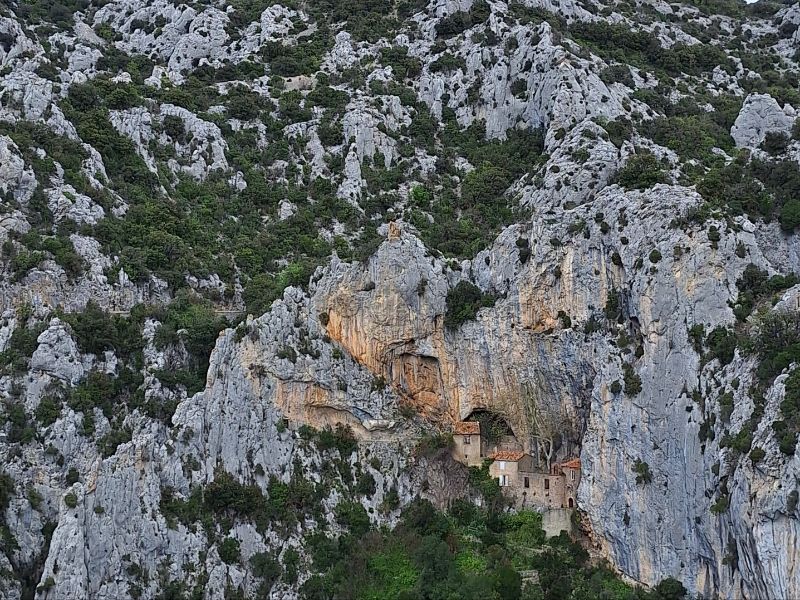
Ermitage de St Antoine
Franciscan monks built the mystical sanctuary of the Ermitage de St Antoine, carved into the almost vertical cliff overlooking the spectacular Galamus gorges, sculpted by nature and the Agly River over hundreds of years. It was accessible only by donkey until intrepid abseilers armed with pick axes hacked out the road in 1880.
Afterwards, continue carefully through very narrow gorge as it cuts through the sheer valley walls. Soon pass into the Aude and the road changes to D10. The steep-sided gorge becomes milder, but no less beautiful.
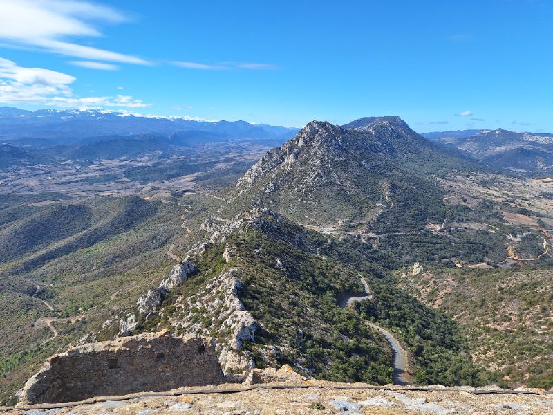
After about 4.5km come to Cubières sur Cinoble and turn right on D14. Stay on this road for about 10km, meandering through the countryside and pastureland to Rouffiac des Corbières, from where you can see the impressive Château de Peyrepertuse high on your right. There is no road access from the north of the castle, so keep going 3km to Duilhac-sous-Peyrepertuse, from where you can visit it if you desire.
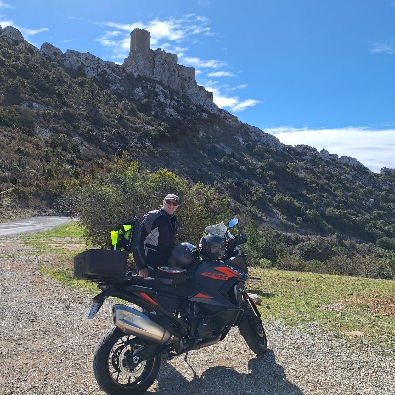
From here, follow D14 a further 4km until just before Cucugnan. Turn right up the hill on the D123 towards Maury. This takes you up to the Col de l’Auzine at 426m, and the turn off for another Cathar castle, Queribus.
Now you are back in the P-O, the road changes to the D19 and after 5km, arrive at the famous wine village of Maury.
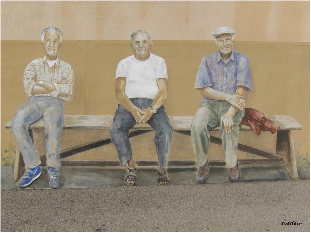
Maury
Well worth the visit for its great wines, it is also a delight in Maury to wander around the “Chemin de Trompe l’Oeil”, tricks of the eye, painted in 1998 by master muralist Bernard Gout.
A dog guards the entrance to the Cave Co-operative. Or does it? Three old men sit on a bench in the sun – or do they? A horse looks over a stable door, a pretty fountain tempts closer inspection. At least the café is open. Isn’t it?
From a distance you’re really not quite sure. Fascinating.
Turn left on D117 towards Estagel, which you reach after about 9km. Now turn right onto bridge over Agly, and follow road into centre of town. Turn right again on D612 towards Millas.
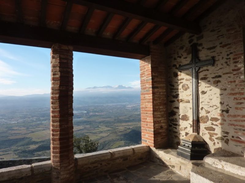
Initially straight towards Montner, but becoming more bendy as it climbs another hill, the road takes you past the Ravin de Caladroy and up to the Col de la Bataille at 264m. Here you can find the turn off for the Força Real if you want to stop at a fantastic viewpoint over the plain of Roussillon.
After this, descend again towards the Têt. This road is great fun if you can do it when it’s not too busy!
Col de la Bataille
After the Treaty of Bayonne, which set the borders between France and Spain, the King of Aragon, Jean II, handed over the Roussillon and the Cerdagne to Louis XI of France.
Years later, Louis’s successor, Charles VIII, decided that the rebellious Roussillonnais were trouble and handed them back to Spain!
In 1496, this fickle king changed his mind again, marched back into the Roussillon and waged war to win back the region, a decisive battle which took place on the Col de la Bataille, as it was subsequently named.
It is on this spot that you will find the memorial to members of the resistance group Henri Barbusse, whose leader Julien Panchot, along with other members of the group, was interrogated, tortured and shot by the Germans whilst defending the villagers of Valmanya.
After you reach the Têt and Millas 13km after Estagel, turn left on D916 and at roundabout, turn right towards Thuir on D612. About 9km from Millas, return to Thuir and your start point.
Enjoy the riding and safe travels! Remember “Mieux vaut être en retard dans ce monde, qu’en avance dans l’autre!”